
Class Start: Private training you can start anytime (1 vs 1)
Total Class: 4 days, One day a week
Class Durations: 2 hours (Each day), Time: Depend on you
Online Training Mode: Google Meet
Language Mode: English
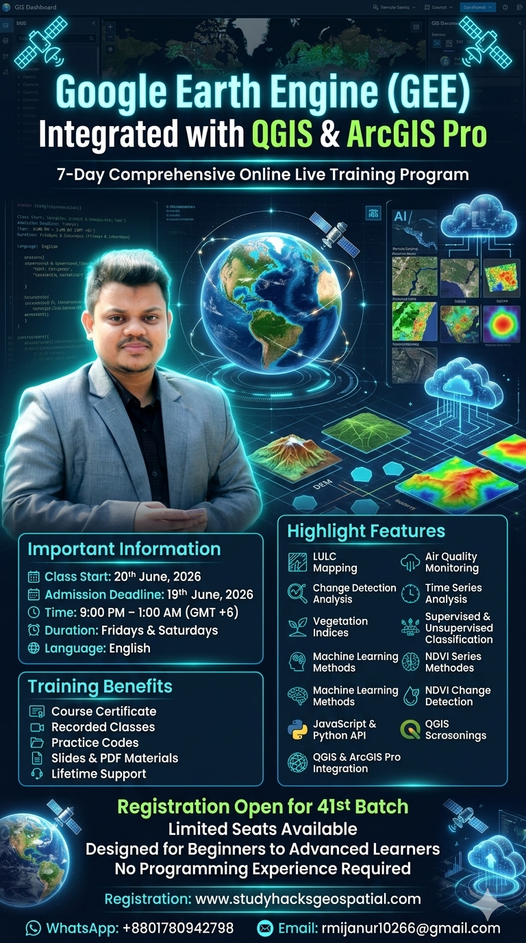
For Registration Contact this Email: rmijanur10266@gmail.com
Or WhatsApp 24/7: Contact
Module 1: Introduction to Remote Sensing for Urban Planning
Objectives:
a) Understand the basics of remote sensing and its significance in urban management.
b) Explore key remote sensing data sources for urban studies.
Topics:
1) Basics of Remote Sensing
2) Satellite Imagery for Urban Areas (e.g., Sentinel, Landsat, MODIS)
3) GIS Integration with Remote Sensing
Activities:
a) Lecture with examples of urban applications.
b) Hands-on: Accessing and visualizing satellite imagery in Google Earth Engine (GEE).
Module 2: Urban Growth and Land Use Analysis
Objectives:
a) Monitor and analyze urban expansion and land-use changes.
b) Assess the environmental impacts of urbanization.
Topics:
1) Monitoring Urban Sprawl with Remote Sensing
2) Land Use Land Cover (LULC) Mapping Techniques
3) Machine Learning for Urban Change Detection
Activities:
a) Case study: Monitoring urban growth in a metropolitan city.
b) Hands-on: LULC classification using GEE.
Module 3: Sustainable Urban Development
Objectives:
a) Explore strategies for mitigating urban heat and improving green spaces.
b) Evaluate urban carbon sequestration potential.
Topics:
1) Urban Heat Island (UHI) Mapping
2) Green Space and Ecosystem Health Monitoring
3) Assessing Carbon Sequestration in Urban Areas
Activities:
1) Practical: Mapping UHI using thermal remote sensing data.
2)Group discussion: Solutions for greener cities.
Module 4: Urban Infrastructure and Utilities
Objectives:
a) Map and analyze urban road networks, transportation, and utilities.
b) Design efficient urban utility systems.
Topics:
1) Remote Sensing for Urban Infrastructure
2) Optimizing Public Transportation Networks
3) Assessing Urban Drainage and Water Systems
Activities:
a) Lab session: Mapping road networks and utilities in GIS.
b) Assignment: Propose solutions for improving urban drainage systems.
Module 5: Disaster Risk Management
Objectives:
a) Use remote sensing to assess disaster risks and urban vulnerabilities.
b) Develop actionable disaster resilience plans.
Topics:
1) Flood Risk Mapping in Urban Areas
2) Earthquake Damage Assessment
3) Urban Fire Risk Monitoring
Activities:
a) Practical: Flood mapping using Sentinel-1 data in GEE.
b) Roleplay: Developing a resilience plan for an urban disaster scenario.
Module 6: Environmental Monitoring in Urban Areas
Objectives:
a) Monitor air and water quality using satellite data.
b) Analyze urban climatic changes and their effects.
Topics:
1) Air Quality Monitoring with Sentinel-5P
2) Water Body Health Assessment in Urban Areas
3) Urban Climate Change Impacts
Activities:
a) Practical: Air quality mapping using Sentinel-5P in GEE.
b) Case study: Assessing urban water body health.
Module 7: Smart Cities and Innovation
Objectives:
a) Apply remote sensing to design smart and sustainable cities.
b) Leverage data for waste management and energy efficiency.
Topics:
1) EV Charging Station Mapping
2) Urban Waste Management Optimization
Energy Efficiency Mapping with Thermal Data
Activities:
a) Project: Mapping suitable locations for EV charging stations.
b) Discussion: The role of smart cities in urban planning.
Module 8: Social and Economic Aspects
Objectives:
a) Analyze urban population density and socio-economic inequalities.
b) Identify poverty hotspots using spatial and spectral data.
Topics:
1) Population Density Estimation
2) Mapping Socio-Economic Inequalities
3) Identifying Urban Poverty Hotspots
Activities:
a) Lab session: Nighttime light data analysis for socio-economic mapping.
b) Debate: Addressing urban inequalities through geospatial data.
Module 9: Heritage and Cultural Preservation
Objectives:
a) Preserve urban cultural sites using geospatial technologies.
b) Assess the impact of urban growth on heritage zones.
Topics:
1) Remote Sensing for Heritage Site Preservation
2) Mapping Urban Tourism Hotspots
3) Monitoring Impacts of Urbanization on Cultural Zones
Activities:
a) Practical: Mapping a heritage zone using satellite data.
b) Assignment: Propose a cultural preservation plan.
Module 10: Policy and Decision Support
Objectives:
a) Use GIS and remote sensing to support urban policy-making.
b) Develop urban resilience plans based on geospatial data.
Topics:
1) Urban Zoning and Planning with GIS
2) Developing Urban Resilience Strategies
3) Identifying Optimal Urban Expansion Areas
Activities:
a) Lab session: Zoning and planning analysis using GIS.
b) Group project: Drafting a policy plan for urban expansion.
Module 11: Challenges and Future Scope
Objectives:
a) Discuss challenges in urban planning using remote sensing.
b) Explore future trends and technologies in geospatial urban management.
Topics:
1) Challenges in Data Availability and Resolution
2) Integrating AI and ML in Urban Analysis
3) Future Trends in Urban Remote Sensing
Module 12: Capstone Project
Objective:
a) Apply knowledge and skills to a real-world urban planning challenge.
Activities:
b) Identify an urban problem (e.g., flood risk, green space, urban sprawl).
c) Analyze using remote sensing and GIS.
d) Develop solutions and present findings.
1,600.00$
WhatsApp us
Reviews
There are no reviews yet.