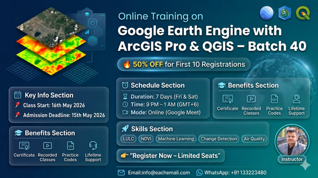
Class Start: Private training you can start anytime (1 vs 1)
Total Class: 7 days, One day a week
Class Durations: 2 hours (Each day), Time: Depend on you
Online Training Mode: Google Meet
Language Mode: English
For Registration Contact this Email: rmijanur10266@gmail.com
Or WhatsApp 24/7: Contact
Fee: 800 USD
Registration is open for Geospatial Analysis With R : Go From Beginner To Advanced level private online training program.
Unlock the Power of Geospatial Analysis in R: Mastering Beginner to Advanced Techniques.
What you’ll learn:
1) To learn the basics of R Programming
2) To carry out the geospatial analysis in R programming
3) To perform geospatial operations using Vector and Raster Data
4) To do the GIS based research using R programming
5) To create the static, interactive and animated map in R
Course Syllabus:
Day 1: Introduction to R for GIS and Remote Sensing 🖥️
Installing and setting up R and RStudio.
Introduction to R syntax, data types, and basic operations.
Importing and exporting data (CSV, Excel, shapefiles, etc.).
Understanding vector and raster data.
Installing and using spatial packages (sf, sp, terra).
Reading and visualizing spatial data.
Handling Coordinate Reference Systems (CRS).
Day 2: Vector Data Analysis in R 📍
Creating and editing spatial vector data.
Calculating geometric attributes (e.g., area, length).
Spatial joins and attribute table operations.
Buffering, clipping, and intersecting geometries.
Point-in-polygon analysis.
Overlay analysis using real-world datasets.
Day 3: Raster Data Analysis in R 🗺️
Loading and visualizing raster data with raster and terra.
Understanding raster resolutions and projections.
Extracting pixel values.
Reclassifying and resampling raster data.
Raster calculations and map algebra.
NDVI calculation from Landsat or Sentinel data.
Day 4: Remote Sensing Data Processing 🛰️
Understanding satellite data (MODIS, Sentinel, Landsat).
Accessing remote sensing data in R using rgee, MODIStsp, and sen2r.
Preprocessing satellite data (cloud masking, cropping, mosaicking).
Calculating vegetation indices (NDVI, EVI, SAVI).
Analysis of temporal changes using time-series data.
Vegetation monitoring over a specific region.
Day 5: Advanced Spatial Analysis 🌍
Interpolation techniques (IDW, Kriging).
Terrain analysis (elevation, slope, aspect) using DEM data.
Hydrological modeling: Flow accumulation and watershed delineation.
Spatial machine learning using caret and ranger.
Supervised classification of satellite imagery.
Accuracy assessment (confusion matrix, kappa statistic).
Day 6: Visualization and Mapping 🖌️
Creating static maps using ggplot2 and tmap.
Advanced mapping techniques: Faceted maps, thematic maps.
Customizing legends, titles, and color scales.
Building interactive maps with leaflet.
Integrating remote sensing data into web maps.
Publishing web maps and sharing results.
Day 7: Case Studies and Practical Applications 📊
Real-world case study 1: Land Use Land Cover (LULC) mapping.
Real-world case study 2: Drought monitoring using SPI and NDVI.
Presenting project results by participants.
Best practices for geospatial analysis in R.
1,500.00$
WhatsApp us
Reviews
There are no reviews yet.