Advanced GIS and Remote Sensing Analysis with ArcGIS

5 Available Seats with 50% Discount
(2 customer reviews)
Google Earth Engine training

Course Contents

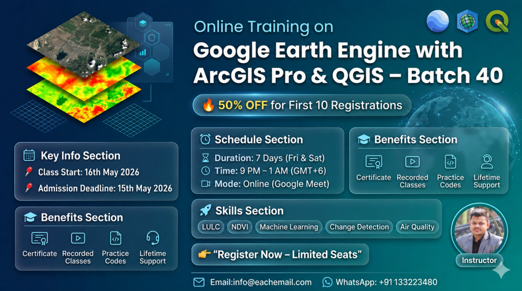
Class Start: Any time privately you can start.

For registration contact this WhatsApp number: +8801780942798 or email: rmijanur10266@gmail.com

Total Class: 20+ days (one day in a week)

Class Duration: 2 hours (Each day)

Time: depends on you

Training language: English

  • 1. Introduction and Overview of GIS
  • – Understanding the fundamentals of Geographic Information Systems.
  • 2. Data and Spatial Data Model
  • – Exploring different types of data and spatial data models.
  • 3. GIS Maps, Map Projection, and Coordinate System
  • – Navigating through GIS maps, map projections, and coordinate systems.
  • 4. Introduction to ArcGIS Desktop
  • – Familiarizing with the ArcGIS Desktop environment.
  • 5. Managing Data with ArcCatalog:
  • – Learning data management techniques using ArcCatalog.
  • 6. Digitization and Data Capture from Maps:
  • – Acquiring skills in digitization and capturing data from maps.
  • 7. Spatial Analysis:
  • – Understanding spatial analysis techniques.
  • 8. Suitability Mapping:
  • – Applying GIS for suitability mapping scenarios.
  • 9. River Erosion and Accretion:
  • – Analyzing river erosion and accretion using GIS.
  • 10. Interpolation Techniques:
  • – Exploring methods for spatial data interpolation.
  • 11. River Density / Drainage Density
  • – Analyzing river density and drainage patterns.
  • 12. River Stream
  • – Studying river stream characteristics.
  • 13. Catchment Area
  • – Defining and analyzing catchment areas.
  • 14. Flood Susceptibility
  • – Assessing flood susceptibility through GIS.
  • 15. DEM- Understanding Digital Elevation Models.
  • 16. Slope, Aspect, Hill Shade
  • – Analyzing terrain characteristics.
  • 17. Determining distances to road networks.
  • 18. Calculating distances to river networks.
  • 19. Introduction to Remote Sensing: -Introducing the basics of remote sensing.
  • 20. Landslide Mapping:- Mapping and analyzing landslide-prone areas.
  • 21. NDVI Mapping -Utilizing Normalized Difference Vegetation Index for mapping.
  • 22. NDVI Classification: – Classifying NDVI data for vegetation analysis.
  • 23. SAVI (Soil-Adjusted Vegetation Index)
  • 24. Performing calculations on raster data.
  • 25. Mapping Land Use and Land Cover changes and detecting alterations.
  • 26. Accuracy of LULC:
  • – Evaluating the accuracy of Land Use and Land Cover mapping.
  • 27. Generating contour maps for topographic representation
  • 28. LST Mapping using ArcMap:
  • – Mapping Land Surface Temperature
  • 29. Incorporating CSV location data into GIS projects
  • 30. Geological Mapping using ArcMap:
  • – Applying GIS for geological mapping and analysis.

2 reviews for Advanced GIS and Remote Sensing Analysis with ArcGIS

  1. عيسى الجبوري

    امتياز

  2. DUSHIMIMANA Remy

    Very helpful course for future spatial planners mostly for youths

Add a review

Latest Course

1,000.00$

Online Training Benefits