Class Start: Any time for private ( 1 vs 1)
Admission Last Date:
Booking last Date:
For Registration Contact this Email: rmijanur10266@gmail.com
Or WhatsApp 24/7: Contact
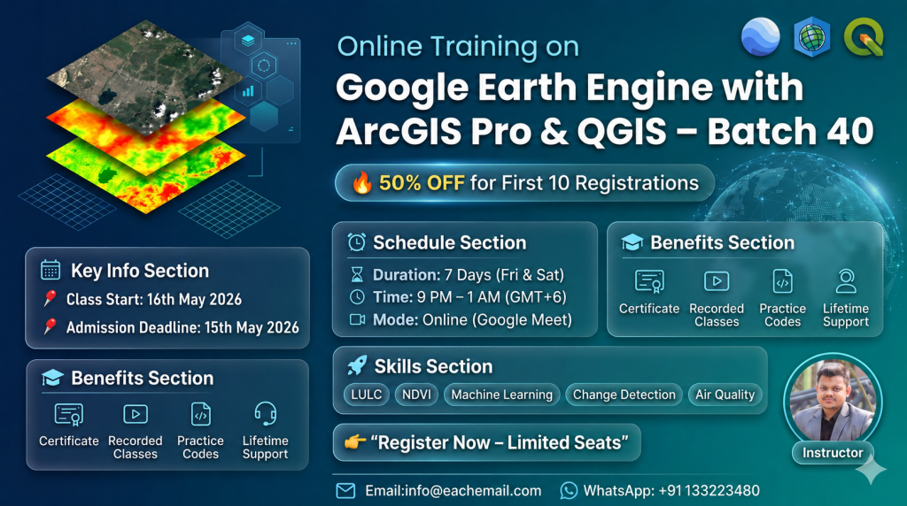
Total Class: 7 days (one class in Week)
Class Durations: 3 hours (Each day),
Online Training Mode: Google Meet
Language Mode: English
| Day | SCHEDULE | Course Contents | Duration |
|---|---|---|---|
| 1st day | 1. IntOverview of GEE: Capabilities and Applications 2. Setting up Google Earth Engine 3. Understanding the GEE Interface and Datasets 4. Setting up the Python environment for GEE 5. Installing necessary libraries (earthengine-api, geemap, etc.) 6. Authenticating and initializing GEE in Python 7. Basic operations with the GEE Python API (loading datasets, basic image operations) |
3 Hours | |
| 2nd | 1. Introduction to Remote Sensing and Satellite Data 2. Common satellite datasets (Landsat, Sentinel, MODIS) 3. Accessing and visualizing satellite images in GEE 4. Image collection filtering (date, location, cloud cover) 5. Image masking, clipping, and reducing 6. Exporting images and data from GEE |
3 Hours | |
| 3rd | 1. Introduction Machine learning 2. Supervised and Unsupervised 3. Overview of Machine Learning: Definitions and Applications 4. Types of ML algorithms (supervised, unsupervised, reinforcement learning) 5. Introduction to popular Python ML libraries (scikit-learn, TensorFlow, Keras) 6. Extracting features from satellite images 7. Preparing datasets for ML training 8. Splitting data into training and testing sets |
3 Hours | |
| 4th | 1. Introduction to supervised learning models (Linear Regression, Decision Trees, Random Forests) 2. Training and testing models with satellite data 3. Evaluating model performance 4. Land cover classification using Random Forest 5. Vegetation index prediction using Linear Regression |
3 Hours | |
| 5th | 1. Overview of Deep Learning: Neural Networks, CNNs 2. Differences between ML and DL 3. Introduction to TensorFlow/Keras for Deep Learning 4. Preparing satellite data for DL models 5. Implementing Convolutional Neural Networks (CNNs) for image classification 6. Training and evaluating CNN models with satellite imagery |
3 Hours | |
| 6th | 1. Transfer Learning and Pre-trained Models 2. Implementing UNet for semantic segmentation 3. Applying Transfer Learning for land cover classification 4. Using UNet for high-resolution mapping |
3 Hours | |
| 7th | 1. Discussing real-world applications (deforestation monitoring, urban planning, disaster management) 2. Case studies showcasing the integration of GEE and ML/DL 3. Start a capstone project that integrates all the concepts learned 4. Work on project presentation and documentation |
3 Hours | |
1,500.00$
WhatsApp us
Reviews
There are no reviews yet.